MASTERSTUDIENGANG - ENVIRONMENTAL DESIGN
Entwurf - Antwerpen, Het Eilandje: Mexicoeiland/Kempeneiland
A City as a MountainEntwurf - Antwerpen, Het Eilandje: Mexicoeiland/Kempeneiland
Lena Müller, Sarah Böttcher, Levin Schmitz-Lenders, Februar 2015
aus dem Workshop November 2014
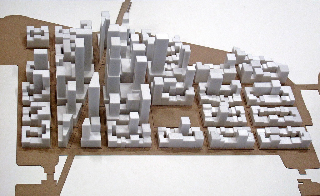
From the plots to the skyscraper – Similar to the founding structure of the Dutch for ‘Nieuw Amsterdam’ on Manhattan later on New York this model of a transformation should be drawn upon the Mexicoeiland in Antwerp. The Commissioners’ Plan from 1811 as implementation of a general parcelling map from Amsterdam became the layer of a whole island like a grid without hierarchy. The ensuing development of an intrinsic building law gradually getting the Zoning Law produced this skyline of a metropolis. At first the codification of a fragmented scale, the rupture like the Broadway, side-specific character of local interests (financial district), the neighborhood of different scales and the continuity of perimeter block development. This gave the principles of an intimately connected framework with freedom of construction as a potential of a monumental scale beside a granularity of distinguished plots of the terrace. To gain this urban suspense the presented project first at all was conceived as a system of basic rules thought as a ‘regulation of disorder’. This should raise the city to a mountain. The design is the simulation of the developed rules like a process. The process is driven from the particularity of the public space (topographic prominence: view with the peak on MAS and Cathedral on Straatsburgbrug and Mexicostraat crossing central view east-west direction to the district Dam) and dynamic system of zoning-laws (freedom of heights regulation with the combination of plots). The basic module gets its scale from the manly size of the inner city parcels of Antwerp.
Konzept
Von der Parzelle zum Hochhaus: Ähnlich wie die Niederländer mit „Nieuw Amsterdam“ einst die Wurzeln auf Manhattan für das spätere New York legten, soll dieses Modell einer Transformation auf Mexicoeiland in Antwerpen übertragen werden. Der „Commissioners’ Plan“ von 1811 sah eine Übertragung des Parzellierungssystems von Amsterdam vor, das als hierarchiefreies Netz über eine Insel gelegt wurde. Die in der Folgezeit einsetzende Entwicklung mit der eigenständig sukzessive geschaffenen Bauordnung („Zoning Law“) ergab diese imposante Silhouette einer Großstadt. Das Ergebnis einer zunächst kleinteiligen Kodierung, den Brüchen (z.B. Broadway), von ortsspezifischen Interessen an einer Lage, den Nachbarschaften unterschiedlicher Maßstäbe und einer konsequenten Blockrandbebauung. Hieraus ergab sich prinzipiell ein eng verknüpftes Übereinander von Regelwerk und Baufreiheit, ein Potenzial zur monumentalen Größe neben identifikationsstarker Kleinteiligkeit. Für diese Spannung wurde in dem hier präsentierten Projekt ein Regelwerk entwickel, eine „geordnete Anarchie“ soll den Stadtteil zu einem ‚Berg‘ erheben. Der Entwurf stellt somit die Simulation des entwickelten Regelwerks im Sinne eines Prozesses dar. Der Prozess wird geleitet von der Besonderheit einiger Orte (Prominenz der Lage: Sichtachse und Hochpunkt Straatsburgbrug und Mexicostraat auf das MAS und die Kathedrale in Kreuzung mit der zentralen Ost-West-Achse zum Stadtteil Dam) und einem dynamischen System von Abstandsregeln (Freiheiten in der Höhenregulierung bei Zusammenlegung von Parzellen). Das Grundmodul entspricht dem vorwiegenden Parzellenmaß in der Altstadt von Antwerpen.
Schwarzplan und Rahmenplan M.: 1:1000
Vertiefung M.: 1:500
Schnitt ost-west M.: 1:500
Schnitt nord-süd M.: 1:500

Blick von Süden
Modell M.: 1:500
Modell M.: 1:1000
Modell M.: 1:2000