MASTERSTUDIENGANG - ENVIRONMENTAL DESIGN
Entwurf: Dockland – La Spezia
Harbour Edge La Spezia / Hafenkante La SpeziaEntwurf: Dockland – La Spezia
Aline Gonsior, Desiree Spahn, Wintersemester 2017/2018
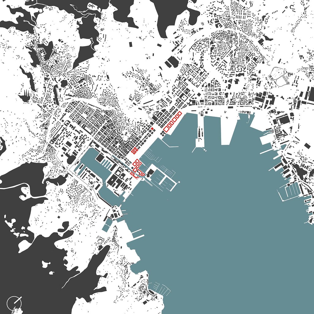
The northern Italian town of La Spezia is located on a strip of land bordered by mountains in the north and west. In the south, the sea forms the border of the city.
The port is still considered to be one of the most important naval locations in Italy. In addition to the economic aspects of shipping, navy and tourism play an important role for the city's inhabitants. All these areas come together at the harbour edge of La Spezia. Since this is insufficiently planned, the draft deals with the task of rear-ranging the harbour edge in terms of urban planning, thus positively influencing the development of the city and giving it a new image of itself.
La Spezia’s geographical location and especially its topographical features have created an irregular urban structure, which gives the city a special character. There are very clear structures in the central area of the city. The streets run in a grid pattern. The existing development consists mainly of perimeter block development. The structure dissolves towards the mountains. The paths there run like serpentines and the buildings become smaller. In contrast to the Centro Historico with mixed use of commercial and residential areas, there are mainly smaller residential buildings. The city’s container port is located directly by the water. On the southeastern side is the tourist Porto Mirabello on an island. On the opposite side of the port is La Spezia’s military area, which is very separated from the rest of the city. The most important points of the city are the Museo Tecnico Navale, the railway station, the tourist port, the pier, the park Giardini Pubblici, the Passeggiata Constantino Morin, the shopping street Via del Prione and the Piazza Europa with the imposing Cattedrale di Cristo Re.
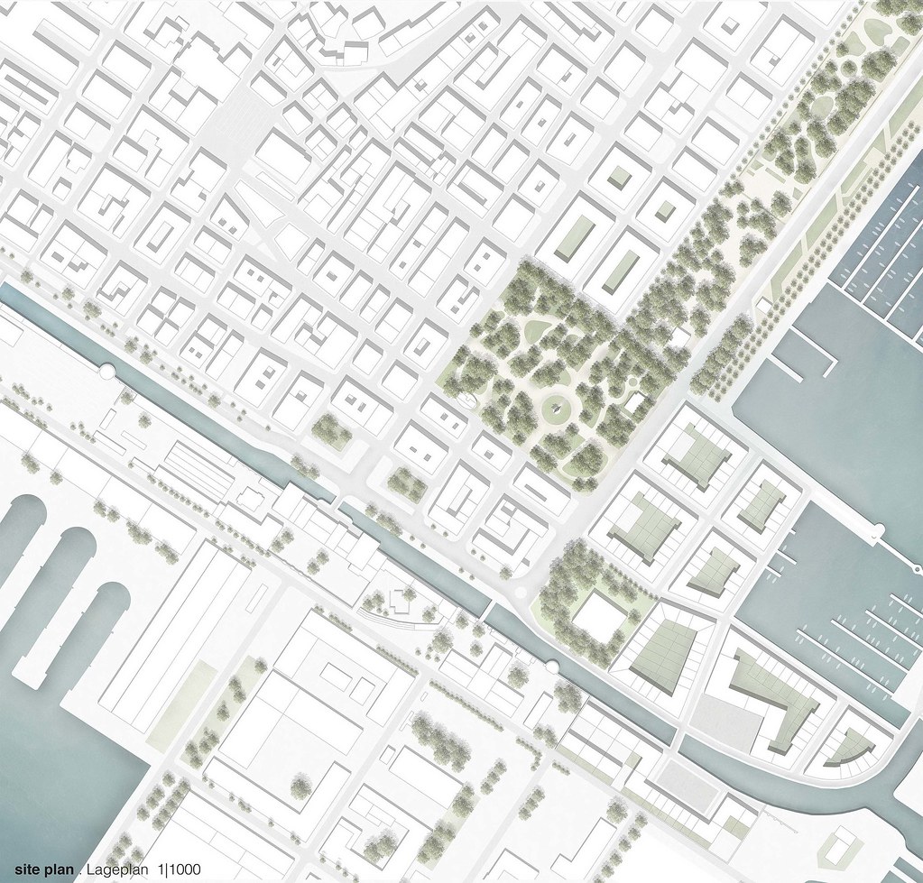
Masterplan 1:1000
Die norditalienische Stadt La Spezia liegt auf einem Landstreifen der im Norden und Westen durch Berge begrenzt wird. Im Süden bildet das Meer die Grenze der Stadt.
Der Hafen gilt immer noch als einer der wichtigsten Marinestandorte Italiens. Für die Bewohner der Stadt spielen neben dem wirtschaftlichen Bereich der Schifffahrt außerdem die Marine und der Tourismus eine wichtige Rolle. All diese Are-ale treffen an der Hafenkante La Spezias zusammen. Da diese unzureichend beplant ist, befasst sich der Entwurf mit der Aufgabe, die Hafenkante städtebaulich neu zu ordnen und so die Entwicklung der Stadt positiv zu beeinflussen und ihr neues Selbstbild zu geben.
Durch die geografische Lage und besonders die topografischen Gegebenheiten ist in La Spezia eine unregelmäßige urbane Struktur entstanden, welche der Stadt einen besonderen Charakter verleiht. Im zentralen Bereich der Stadt gibt es sehr klare Strukturen. Die Straßen verlaufen rasterförmig. Die vorhandene Bebauung besteht vorwiegend aus Blockrandbebauung. In Richtung der Berge löst sich die Struktur auf. Die Wege verlaufen dort serpentinenartig und die Gebäude werden kleinteiliger. Im Gegensatz zum Centro Historico mit Mischnutzung aus Gewerbe und Wohnbereichen findet man dort vor-wiegend niedrigere Wohngebäude. Direkt am Wasser befindet sich nördlich der Containerhafen der Stadt. Auf der südöstlichen Seite befindet sich der Touristenhafen Porto Mirabello auf einer auf-geschütteten Insel.
Auf der südöstlichen Seite befindet sich der Touristenhafen Porto Mirabello auf einer aufgeschütteten Insel. Auf der gegenüberliegenden Seite des Hafens befindet sich zudem La Spezias Militärgebiet das sehr abgegrenzt von der restlichen Stadt liegt. Zu den wichtigsten Punkten der Stadt gehören das Museo Tecnico Navale, der Bahnhof, der Touristenhafen, die Mole, die Parkanlagen Giardini Pubblici, die Passegiata Constantino Morin, die Einkaufsstraße Via del Prione und der Piazza Europa mit der imposanten Cattedrale di Cristo Re.
Urban detail of the westward ‘little’ new harbour 1:500
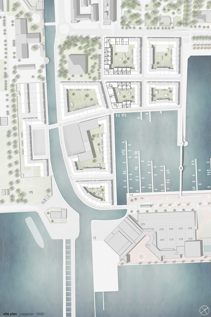
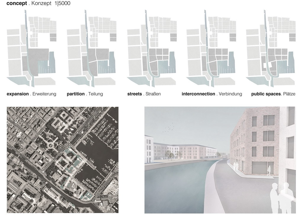
The arrangement of several interventions across the entire harbour edge is intended to complement the existing urban structure and complete La Spezia’s cityscape. By placing new buildings, the public parks Giardini Pubblici and the harbour basin are framed. The Giardini Pubblici and the Passegiata thus become even more of a central green belt of the city and enhance the quality of the port. Between the military base Arsenale Militare Marittimo and the tourist port Porto Mirabello, a connection between the port and the city is reached through the construction site.
The original very small-scale development will be replaced by mixed-use multi-storey construction, which will make the area more attractive to tourists and residents.
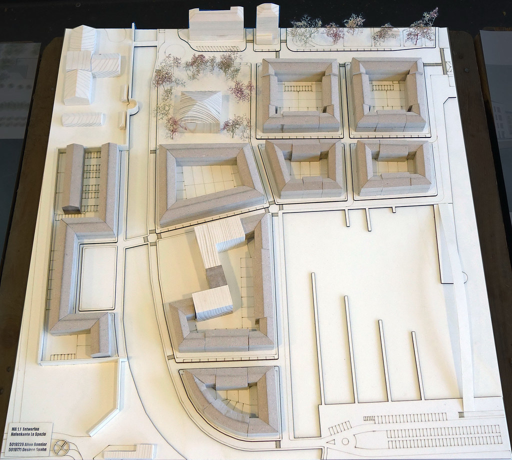
Initially, the area was divided into coarse building plots, which were subsequently refined by the inclusion of existing path structures. Thus, a new quarter is being built in block perimeter development, which with its building heights makes a compromise between the city and military area and thus creates a transition between the areas. The river flows around the new area, the Porto Mirabello is now connected to it by a bridge. The arrangement of the buildings and the preservation of the stock on both sides of the city and the military will create two squares, which will link the two areas and ensure quality of stay. The boundaries are dissolved and the separation wall is given a new course in this area.
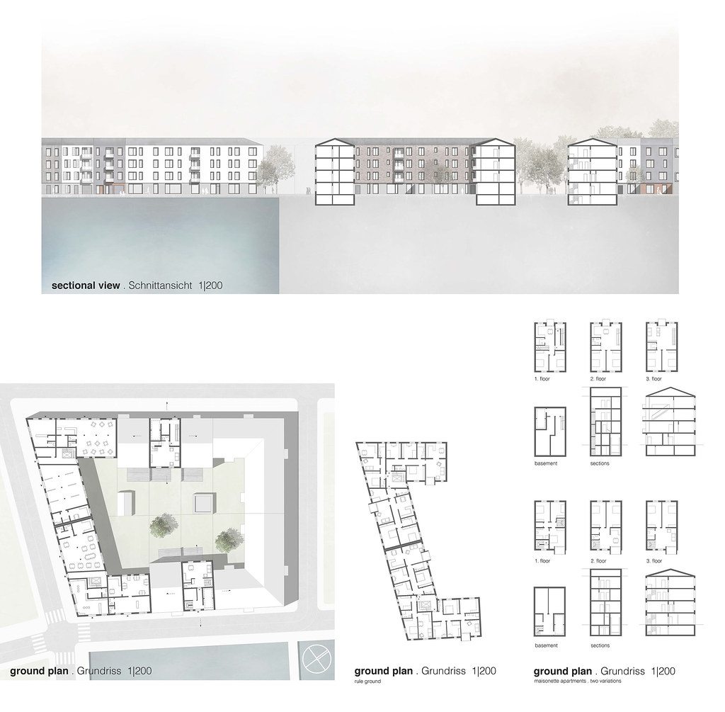
Urban details 1:200
Die Anordnung mehrerer Interventionen über die gesamte Hafenkante hinweg soll die vorhandene Stadtstruktur ergänzen und La Spezias Stadtbild vervollständigen. Durch die Platzierung neuer Gebäude sollen die öffentlichen Parkanlagen Giardini Pubblici und das Hafen-becken eingefasst werden. Die Giardini Pubblici und die Passegiata rücken so noch mehr als zentrales grünes Band der Stadt in den Fokus und steigern die Qualität des Hafens.
Zwischen dem Militärstützpunkt Arsen-ale Militare Marittimo und dem Touristenhafen Porto Mirabello wird durch das angelegte Baufeld eine Verbindung des Hafens mit der Stadt erreicht.
Die ursprüngliche sehr kleinteilige Bebauung wird durch Geschossbauweise mit Mischnutzung ersetzt und soll das Gebiet für Touristen und Anwohner attraktiver machen.
Dabei wurde das Gebiet zunächst in grobe Baufelder gegliedert, welche an-schließend durch die Aufnahme bereits gegebener Wegstrukturen verfeinert wurde. So entsteht ein neues Viertel in Blockrandbebauung, das mit seinen Gebäudehöhen einen Kompromiss zwischen Stadt und Militärgebiet eingeht und so einen Übergang der Areale zu-einander schafft. Der Fluss umfließt das neue Gebiet, der Porto Mirabello ist nun durch eine Brücke mit diesem verbunden. Durch die Anordnung der Gebäude und die Erhaltung des Bestands sowohl auf Seiten der Stadt als auch des Militärs entstehen zwei Plätze, die beide Area-le verknüpfen und für Aufenthaltsqualität sorgen. Die Grenzen werden aufgelöst und die Trennmauer erhält in diesem Be-reich einen neuen Verlauf.
Model morphology 1:2000
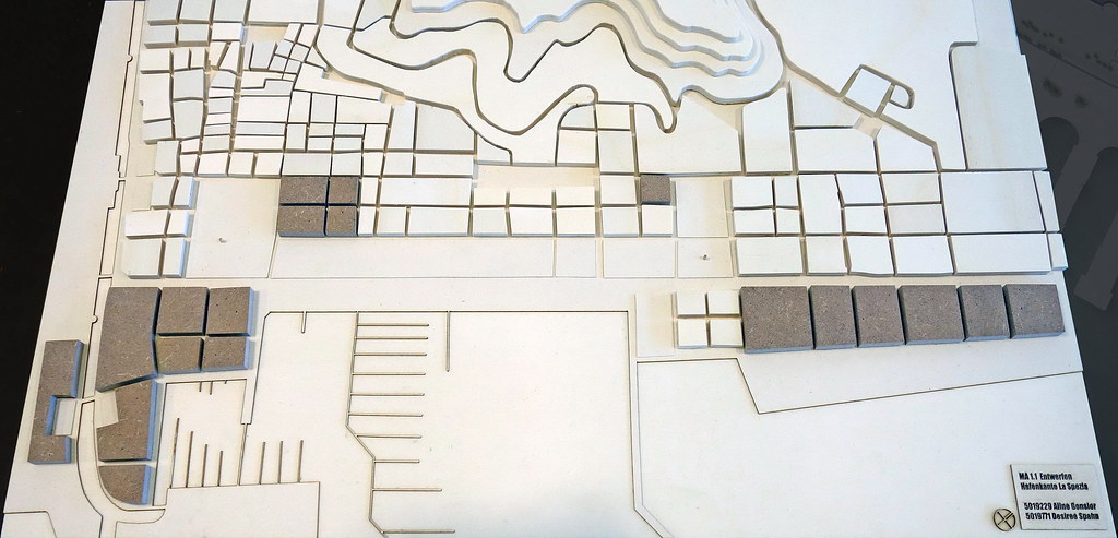
Model 1:500, Junction to the Arsenale, Canale Lagora