MASTERSTUDIENGANG - ENVIRONMENTAL DESIGN
Bordeaux : L’Urbanisation du Campus – Ein Campus wird zur Stadt
From Esplanade des Antilles to Ruisseau d'ArsBordeaux : L’Urbanisation du Campus – Ein Campus wird zur Stadt
Valentina Lange, Gesa Werfelmann, Wintersemester 2018/2019
D’Esplanade des Antilles à Ruisseau d'Ars / Von der Esplanade des Antilles bis zum Ruisseau d'Ars
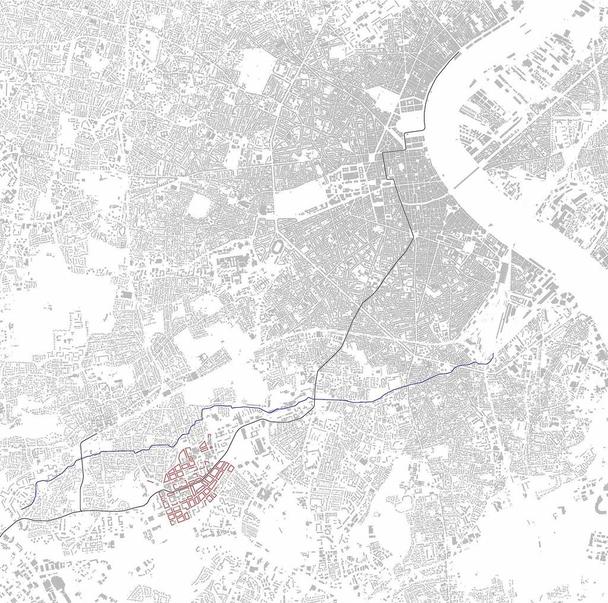
We have been working on the western part of the campus of the University of Bordeaux. This part can be seen here in red. The area does not only include university buildings, but also forms its own mixed-use quarter.
The tram leads from Pessac, through the planned area to the city centre and is therefore a good connection.
The Ruisseau d'Ars runs above the developed area.
The building plots are clearly structured and the size is based on the surrounding building plots.
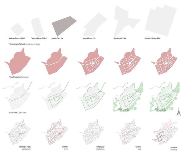
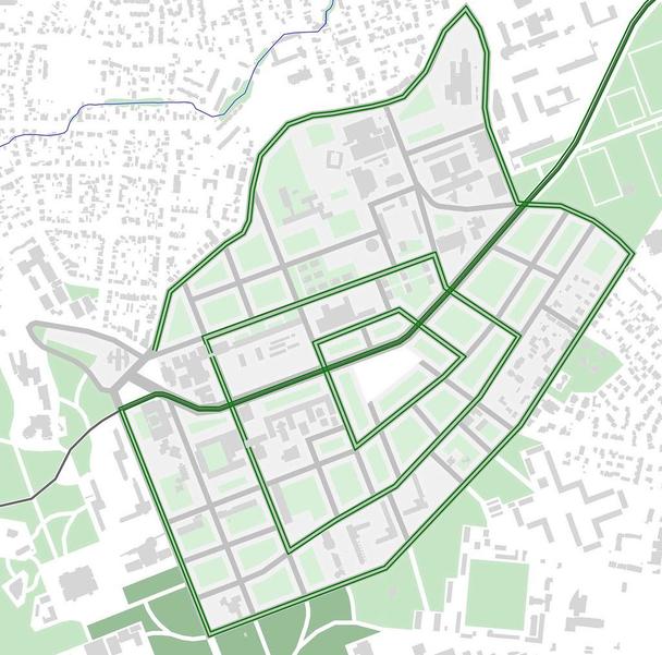
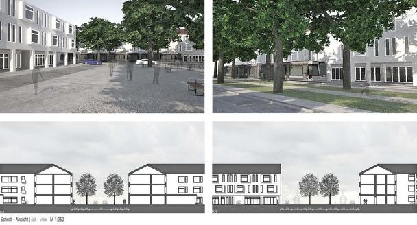
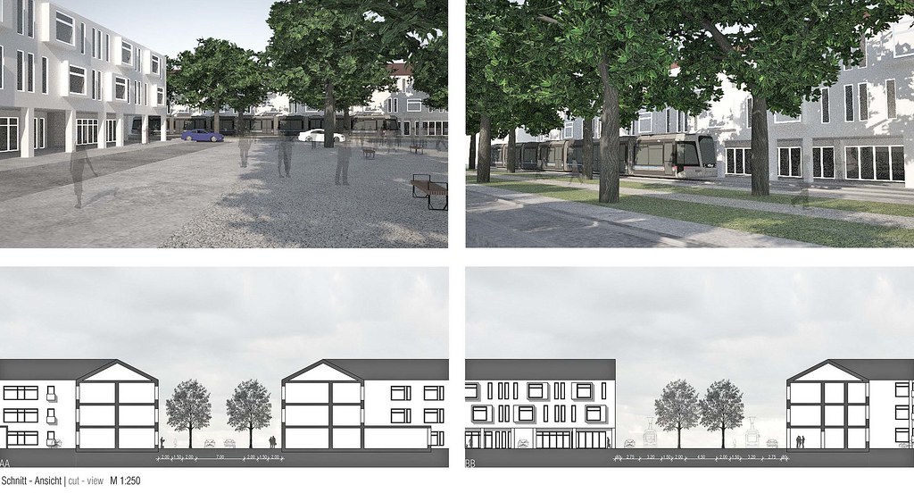
The pictogram shows how the streets have developed. The main street runs along the tram and is built like a boulevard. It is 25 m wide and is the widest street in the area. Here you can find all kinds of traffic, from trams, cars, cycle tracks to a walkway under trees.
Other streets form two rings around a central square, they are 18 metres wide.
In addition, there are side roads and connecting roads to the neighbouring villages.
Avenues with two rows of trees are planned both along the boulevard and along the rings. The avenue along the main road will continue towards Bordeaux City to connect the area with the city centre. In addition, the area will be framed by two rows of trees which will connect it to the existing neighbouring areas. To the west of the area, the university grounds will be surrounded by several small green areas.
To the south, the area ends with a wooded area with walking ways and further green areas are planned in the south-east. In the north-east of the area there are sports fields of the university. Along the Ruisseau d'Ars smaller green areas are also planned.
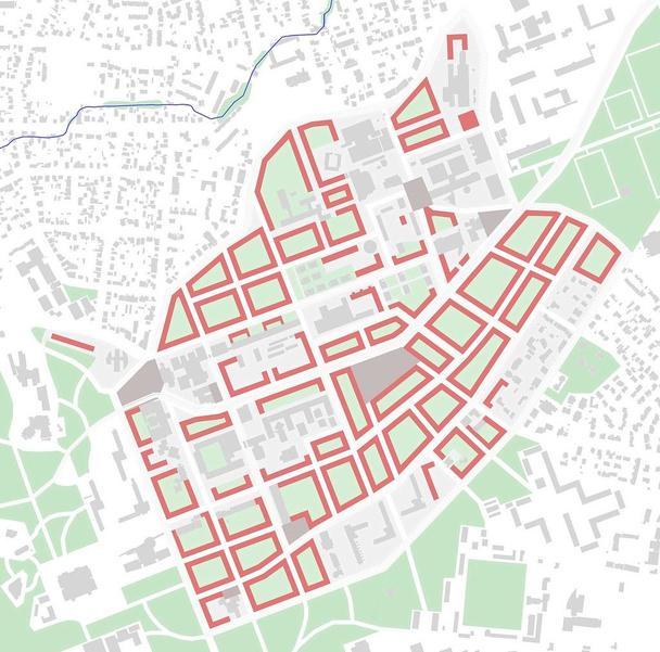
When planning the buildings, care was taken to keep all existing buildings. There is as closed a construction as possible in order to give the existing buildings and the entire area a clear structure. The closed construction is inspired by the largely closed blocks in downtown Bordeaux to create a structural connection.
There are several smaller squares throughout the area, two of them along the tramway. These squares can be used, for example, as playgrounds or general meeting places. To highlight the western entrance to the area, there is a larger square at this point that leads into the area. There is also a central square. This is about 1 ha in size and can be used both as a venue for events and as a general meeting point for people. The size of the place resulted from the analysis of places in Bordeaux and Bremen. The size of the planned square fits between the Place de la Bourse and Place Meynard and fits comparably well to Bordeaux.
The square is framed on three sides by tree fields and the fourth side is closed with two rows of water fountains inspired by the fountains on the Place de la Bourse.
Along the boulevard, the trees are planted the closest, in the first ring the distance between the trees grows larger and in the second ring it grows even larger to represent a differentiation of the streets and to increase the differentiation of the streets and to give an idea of how close you are to the centre. The closer the trees are to each other, the closer you are to the centre of the area.
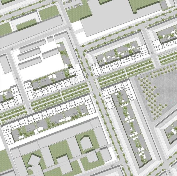
During the parcelling process, we planned parcels in the central area, which can be built on, for example, with multi-family houses or commercial buildings. In the areas near the existing family houses, there are smaller plots where terraced houses can be built. The university buildings are distributed on larger plots, the gaps of which we have covered with new buildings. In the courtyards there is space for smaller buildings, which can be used as garden houses or garages. There is also space for commercial plots, which can have a factory in the backyard. Parking also takes place in the inner courtyards. There are also two car sharing stations in the area. At the avenue along the tram are the rows of trees between the lanes. At the rings next to the lanes.
Architecturally, the ring system from urban planning is further underlined by the arcades around the central square. These additionally frame the square and give it a special character. The floor plans show examples of commercial uses on the ground floor, such as a bakery, a library, a café or a restaurant, which could be located there. In addition, the driveways to the backyards can be seen and the 1st and 2nd floors contain apartments.
Wir haben uns mit dem westlicheren Teil des Campus der Universität Bordeaux beschäftigt. Diesen Teil kann man hier in Rot erkennen. Das Gebiet umfasst nicht nur Universitäre Gebäude, sondern bildet einen eigenen Stadtteil mit gemischter Nutzung. Die Straßenbahn führt von Pessac, durch das geplante Gebiet bis zur Innenstadt und ist somit eine gute Verbindung. Der Ruisseau d'Ars verläuft oberhalb des erarbeiteten Gebiets. Die Baufelder sind klar strukturiert und die Größe orientiert sich an den umliegenden Baufeldern. Wie sich die Straßen entwickelt haben, erkennt man an dem Piktogramm. Die Hauptstraße führt entlang der Straßenbahn und ist wie eine Promenade aufgebaut. Sie ist 25 m breit und damit die breiteste Straße im Gebiet. Hier findet man alle Verkehrsarten, von Straßenbahn, Pkws, Radwegen bis hin zu einem Fußweg unter Bäumen. Weitere Straßen bilden zwei Ringe um einen zentralen Platz, diese sind 18 m breit. Hinzu kommen dann Nebenstraßen und Verbindungsstraßen zu den Nachbarorten.
Sowohl entlang der Promenade, als auch entlang der Ringe sind Alleen mit zwei Baumreihen geplant. Die Allee entlang der Hauptstraße wird in Richtung Bordeaux Stadt weiter geführt um das Gebiet mit der Innenstadt zu verbinden. Außerdem wird das Gebiet von zwei Baumreihen umrahmt die es mit den vorhandenen Nachbargebieten verbindet. Westlich von dem Gebiet wird das Unigelände von mehreren kleinen Grünflächen umhüllt.
Südlich schließt das Gebiet mit einem Waldstück mit Spazierwegen ab und im Süd-Osten sind weitere Grünflächen angedacht. Im Nord-Osten des Gebietes befinden sich Sportplätze der Uni. Entlang des Ruisseau d'Ars sind ebenfalls kleinere Grünflächen geplant.
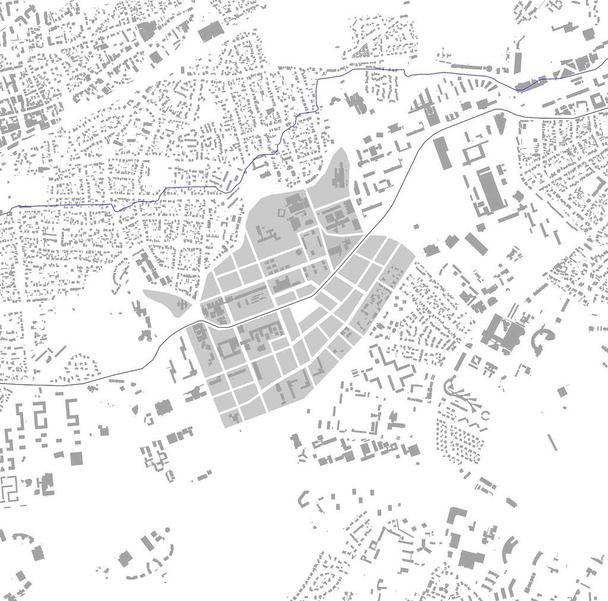
Morphology 1:5000
Beim Planen der Gebäude wurde darauf geachtet, dass alle Bestandsgebäude beibehalten werden. Es gibt eine möglichst geschlossene Bauweise, um den vorhandenen Gebäuden und dem gesamten Gebiet eine klare Struktur zu geben. Die geschlossene Bauweise ist inspiriert von den größtenteils geschlossenen Blöcken in der Innenstadt von Bordeaux, um eine strukturelle Verbindung zu schaffen.
Es ziehen sich durch das gesamte Gebiet mehrere, kleinere Quartiersplätze, zwei davon befinden sich entlang der Straßenbahn. Diese Plätze können z.B. als Spielplätze oder als allgemeine Treffpunkte genutzt werden. Um den westlichen Eingang des Gebietes hervorzuheben, befindet sich an dieser Stelle ein größerer Platz, welcher in das Gebiet hineinleitet. Außerdem gibt es einen zentralen Platz. Dieser ist circa 1 ha groß und kann sowohl als Veranstaltungsort, als auch als allgemeiner Treffpunkt von Bewohnern genutzt werden. Die Größe des Platzes ergab sich durch die Analyse von Plätzen in Bordeaux und Bremen. So passt der geplante Platz größentechnisch zwischen den Place de la Bourse und Place Meynard und passt verhältnismäßig gut nach Bordeaux.
Der Platz wird an drei Seiten mit Baumfeldern umrahmt und die vierte Seite wird mit zwei Reihen von Wasserfontänen geschlossen, diese sind inspiriert von den Fontänen auf dem Place de la Bourse.
Entlang der Promenade sind die Bäume am dichtesten gepflanzt, im ersten ring wird der Abstand zwischen den Bäumen größer und im zweiten ring noch größer, um eine Abstufung der Straßen dar zu stellen und um die Unterscheidung der Straßen zu erhöhen und einen Hinweis darauf zu geben, wie nah man an dem Zentrum ist. Je näher die Bäume aneinander stehen, umso näher ist man dem Kern des Gebiets.
Bei der Parzellierung haben wir im zentralen Bereich Parzellen geplant, die z.B. mit Mehrfamilienhäusern oder gewerblich genutzten Gebäuden bebaut werden können. In den Bereichen, die bei den bestehenden Einfamilienhäusern liegen, gibt es kleinere Parzellen auf denen Reihenhäuser Platz finden. Die Universitären Gebäude sind auf größere Parzellen verteilt, deren Lücken wir mit neuen Gebäuden bebaut haben. In den Innenhöfen gibt es Platz für kleinere Gebäude, die als Gartenhäuser oder Garage genutzt werden können. Teilweise gibt es auch Platz für gewerblich genutzte Parzellen, die z.B. eine Werkstatt im Hinterhof haben können. Das Parken findet ebenfalls in den Innenhöfen statt. Außerdem gibt es zwei Carsharing Stationen im Gebiet. Bei der Allee entlang der Straßenbahn befinden sich die Baumreihen zwischen den Fahrbahnen. Bei den Ringen neben den Fahrbahnen.
Architektonisch wird das Ringsystem aus dem Städtebau nochmals durch die Arkaden rund um den zentralen Platz unterstrichen. Diese rahmen den Platz zusätzlich ein und geben ihm einen besonderen Charakter. Die Grundrisse zeigen Beilspiele für gewerbliche Nutzungen im Erdgeschoss, wie z.B. eine Bäckerei, eine Bibliothek, ein Café oder ein Restaurant, welche sich dort befinden könnten. Außerdem sind die Durchfahrten zu den Hinterhöfen zu erkennen und in den 1. und 2. Geschossen befinden sich Wohnungen.
The design is located in the western part of the campus of the University of Bordeaux Montaigne and includes a concept of rings based on street widths and plantings. There is a ring around the central square of the design, framed on the one hand by several trees and on the other by two rows of water fountains. The second and third rings are formed by the avenues in the streets. The entire area is also framed by two rows of trees, creating a link between the planned area and the existing one. Through the area, along the tram, there is a promenade, which contains all traffic routes and offers a generous walk under trees.
The closed construction is inspired by the city centre of Bordeaux. In order to create a clear structure and structural link, building blocks are planned for the most part.
There is a large central square of 1ha which can be used for various events, such as a market or university events. On the ground floor around the square there are rooms such as restaurants and bakeries which are available for both students and residents.
There are several small neighbourhood squares throughout the area, which can be used as playgrounds or as meeting places.
Urban structure 1:2500
Der Entwurf befindet sich im westlichen Teil des Campus der Universität Bordeaux Montaigne und beinhaltet ein Konzept von Ringen anhand von Straßenbreiten und der Bepflanzungen. Es gibt einen Ring, der sich rund um den zentralen Platz des Entwurfs befindet und diesen zum einen mit mehreren Bäumen und zum anderen mit zwei Reihen von Wasserfontänen einrahmt. Den zweiten und dritten Ring bilden die Alleen in den Straßen. Das gesamte Gebiet wird ebenfalls von zwei Baum-reihen umrahmt und verbindet so das geplante Gebiet mit dem Vorhandenen. Durch das Gebiet, entlang der Straßenbahn befindet sich eine Promenade, welche alle Verkehrswege beinhaltet und einen großzügigen Spazierweg unter Bäumen bietet.
Die geschlossene Bauweise ist inspiriert von der Innenstadt in Bordeaux. Um eine klare Struktur und eine strukturelle Verbindung zu schaffen, sind größtenteils Gebäudeblöcke geplant.
Es gibt einen großen zentralen Platz von 1ha, der für verschiedenen Veranstaltungen, wie z.B. einen Markt oder Universitäts-veranstaltungen, genutzt werden kann. Im Erdgeschoss um den Platz herum befinden sich Räumlichkeiten wie Restaurants und Bäckereien, die sowohl für die Studierenden als auch für die Bewohner zur Verfügung stehen.
Es ziehen sich durch das gesamte Gebiet mehrere, kleine Quartiersplätze, die z.B. als Spielplätze oder als alleigemeine Treffpunkte genutzt werden können.
Network of roads and greenery 1:2500
Extract 1:1000
Urban detail 1:500
Model 1:500
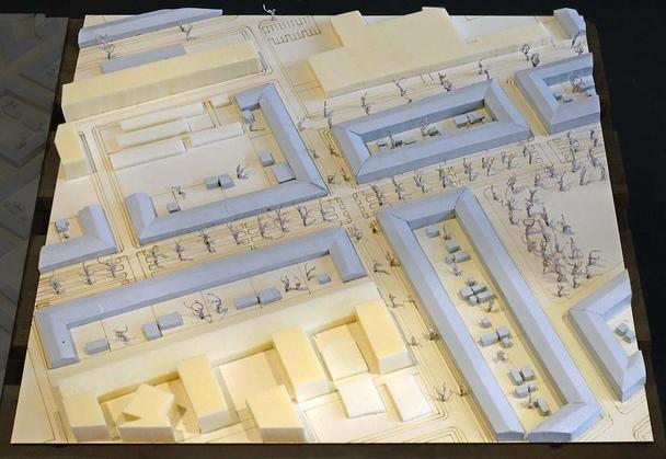
Model 1:500

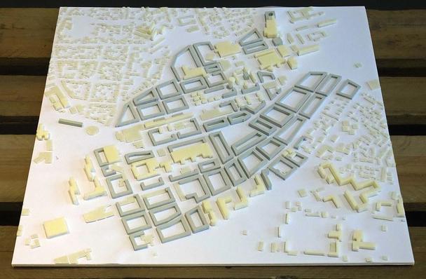
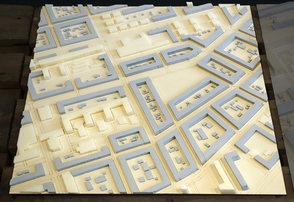
Model 1:1000
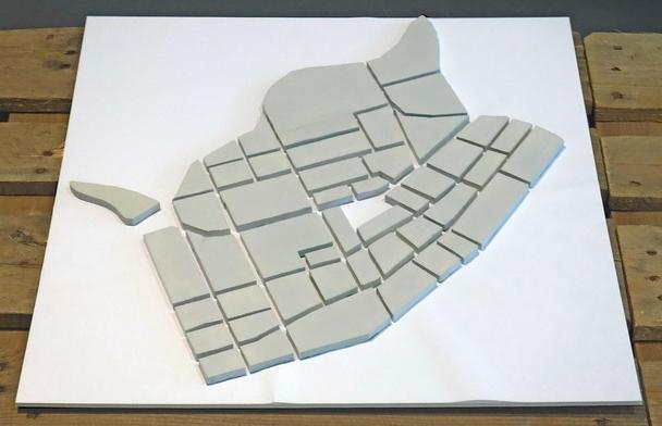
Model 1:2500
We have been working on the western part of the campus of the University of Bordeaux. This part can be seen here in red. The area does not only include university buildings, but also forms its own mixed-use quarter.
The tram leads from Pessac, through the planned area to the city centre and is therefore a good connection.
The Ruisseau d'Ars runs above the developed area.
The building plots are clearly structured and the size is based on the surrounding building plots.
The pictogram shows how the streets have developed. The main street runs along the tram and is built like a boulevard. It is 25 m wide and is the widest street in the area. Here you can find all kinds of traffic, from trams, cars, cycle tracks to a walkway under trees.
Other streets form two rings around a central square, they are 18 metres wide.
In addition, there are side roads and connecting roads to the neighbouring villages.
Avenues with two rows of trees are planned both along the boulevard and along the rings. The avenue along the main road will continue towards Bordeaux City to connect the area with the city centre. In addition, the area will be framed by two rows of trees which will connect it to the existing neighbouring areas. To the west of the area, the university grounds will be surrounded by several small green areas.
To the south, the area ends with a wooded area with walking ways and further green areas are planned in the south-east. In the north-east of the area there are sports fields of the university. Along the Ruisseau d'Ars smaller green areas are also planned.
When planning the buildings, care was taken to keep all existing buildings. There is as closed a construction as possible in order to give the existing buildings and the entire area a clear structure. The closed construction is inspired by the largely closed blocks in downtown Bordeaux to create a structural connection.
There are several smaller squares throughout the area, two of them along the tramway. These squares can be used, for example, as playgrounds or general meeting places. To highlight the western entrance to the area, there is a larger square at this point that leads into the area. There is also a central square. This is about 1 ha in size and can be used both as a venue for events and as a general meeting point for people. The size of the place resulted from the analysis of places in Bordeaux and Bremen. The size of the planned square fits between the Place de la Bourse and Place Meynard and fits comparably well to Bordeaux.
The square is framed on three sides by tree fields and the fourth side is closed with two rows of water fountains inspired by the fountains on the Place de la Bourse.
Along the boulevard, the trees are planted the closest, in the first ring the distance between the trees grows larger and in the second ring it grows even larger to represent a differentiation of the streets and to increase the differentiation of the streets and to give an idea of how close you are to the centre. The closer the trees are to each other, the closer you are to the centre of the area.
During the parcelling process, we planned parcels in the central area, which can be built on, for example, with multi-family houses or commercial buildings. In the areas near the existing family houses, there are smaller plots where terraced houses can be built. The university buildings are distributed on larger plots, the gaps of which we have covered with new buildings. In the courtyards there is space for smaller buildings, which can be used as garden houses or garages. There is also space for commercial plots, which can have a factory in the backyard. Parking also takes place in the inner courtyards. There are also two car sharing stations in the area. At the avenue along the tram are the rows of trees between the lanes. At the rings next to the lanes.
Architecturally, the ring system from urban planning is further underlined by the arcades around the central square. These additionally frame the square and give it a special character. The floor plans show examples of commercial uses on the ground floor, such as a bakery, a library, a café or a restaurant, which could be located there. In addition, the driveways to the backyards can be seen and the 1st and 2nd floors contain apartments.

Wir haben uns mit dem westlicheren Teil des Campus der Universität Bordeaux beschäftigt. Diesen Teil kann man hier in Rot erkennen. Das Gebiet umfasst nicht nur Universitäre Gebäude, sondern bildet einen eigenen Stadtteil mit gemischter Nutzung. Die Straßenbahn führt von Pessac, durch das geplante Gebiet bis zur Innenstadt und ist somit eine gute Verbindung. Der Ruisseau d'Ars verläuft oberhalb des erarbeiteten Gebiets. Die Baufelder sind klar strukturiert und die Größe orientiert sich an den umliegenden Baufeldern. Wie sich die Straßen entwickelt haben, erkennt man an dem Piktogramm. Die Hauptstraße führt entlang der Straßenbahn und ist wie eine Promenade aufgebaut. Sie ist 25 m breit und damit die breiteste Straße im Gebiet. Hier findet man alle Verkehrsarten, von Straßenbahn, Pkws, Radwegen bis hin zu einem Fußweg unter Bäumen. Weitere Straßen bilden zwei Ringe um einen zentralen Platz, diese sind 18 m breit. Hinzu kommen dann Nebenstraßen und Verbindungsstraßen zu den Nachbarorten.
Sowohl entlang der Promenade, als auch entlang der Ringe sind Alleen mit zwei Baumreihen geplant. Die Allee entlang der Hauptstraße wird in Richtung Bordeaux Stadt weiter geführt um das Gebiet mit der Innenstadt zu verbinden. Außerdem wird das Gebiet von zwei Baumreihen umrahmt die es mit den vorhandenen Nachbargebieten verbindet. Westlich von dem Gebiet wird das Unigelände von mehreren kleinen Grünflächen umhüllt.
Südlich schließt das Gebiet mit einem Waldstück mit Spazierwegen ab und im Süd-Osten sind weitere Grünflächen angedacht. Im Nord-Osten des Gebietes befinden sich Sportplätze der Uni. Entlang des Ruisseau d'Ars sind ebenfalls kleinere Grünflächen geplant.
Morphology 1:5000

Beim Planen der Gebäude wurde darauf geachtet, dass alle Bestandsgebäude beibehalten werden. Es gibt eine möglichst geschlossene Bauweise, um den vorhandenen Gebäuden und dem gesamten Gebiet eine klare Struktur zu geben. Die geschlossene Bauweise ist inspiriert von den größtenteils geschlossenen Blöcken in der Innenstadt von Bordeaux, um eine strukturelle Verbindung zu schaffen.
Es ziehen sich durch das gesamte Gebiet mehrere, kleinere Quartiersplätze, zwei davon befinden sich entlang der Straßenbahn. Diese Plätze können z.B. als Spielplätze oder als allgemeine Treffpunkte genutzt werden. Um den westlichen Eingang des Gebietes hervorzuheben, befindet sich an dieser Stelle ein größerer Platz, welcher in das Gebiet hineinleitet. Außerdem gibt es einen zentralen Platz. Dieser ist circa 1 ha groß und kann sowohl als Veranstaltungsort, als auch als allgemeiner Treffpunkt von Bewohnern genutzt werden. Die Größe des Platzes ergab sich durch die Analyse von Plätzen in Bordeaux und Bremen. So passt der geplante Platz größentechnisch zwischen den Place de la Bourse und Place Meynard und passt verhältnismäßig gut nach Bordeaux.
Der Platz wird an drei Seiten mit Baumfeldern umrahmt und die vierte Seite wird mit zwei Reihen von Wasserfontänen geschlossen, diese sind inspiriert von den Fontänen auf dem Place de la Bourse.
Entlang der Promenade sind die Bäume am dichtesten gepflanzt, im ersten ring wird der Abstand zwischen den Bäumen größer und im zweiten ring noch größer, um eine Abstufung der Straßen dar zu stellen und um die Unterscheidung der Straßen zu erhöhen und einen Hinweis darauf zu geben, wie nah man an dem Zentrum ist. Je näher die Bäume aneinander stehen, umso näher ist man dem Kern des Gebiets.
Bei der Parzellierung haben wir im zentralen Bereich Parzellen geplant, die z.B. mit Mehrfamilienhäusern oder gewerblich genutzten Gebäuden bebaut werden können. In den Bereichen, die bei den bestehenden Einfamilienhäusern liegen, gibt es kleinere Parzellen auf denen Reihenhäuser Platz finden. Die Universitären Gebäude sind auf größere Parzellen verteilt, deren Lücken wir mit neuen Gebäuden bebaut haben. In den Innenhöfen gibt es Platz für kleinere Gebäude, die als Gartenhäuser oder Garage genutzt werden können. Teilweise gibt es auch Platz für gewerblich genutzte Parzellen, die z.B. eine Werkstatt im Hinterhof haben können. Das Parken findet ebenfalls in den Innenhöfen statt. Außerdem gibt es zwei Carsharing Stationen im Gebiet. Bei der Allee entlang der Straßenbahn befinden sich die Baumreihen zwischen den Fahrbahnen. Bei den Ringen neben den Fahrbahnen.
Architektonisch wird das Ringsystem aus dem Städtebau nochmals durch die Arkaden rund um den zentralen Platz unterstrichen. Diese rahmen den Platz zusätzlich ein und geben ihm einen besonderen Charakter. Die Grundrisse zeigen Beilspiele für gewerbliche Nutzungen im Erdgeschoss, wie z.B. eine Bäckerei, eine Bibliothek, ein Café oder ein Restaurant, welche sich dort befinden könnten. Außerdem sind die Durchfahrten zu den Hinterhöfen zu erkennen und in den 1. und 2. Geschossen befinden sich Wohnungen.

The design is located in the western part of the campus of the University of Bordeaux Montaigne and includes a concept of rings based on street widths and plantings. There is a ring around the central square of the design, framed on the one hand by several trees and on the other by two rows of water fountains. The second and third rings are formed by the avenues in the streets. The entire area is also framed by two rows of trees, creating a link between the planned area and the existing one. Through the area, along the tram, there is a promenade, which contains all traffic routes and offers a generous walk under trees.
The closed construction is inspired by the city centre of Bordeaux. In order to create a clear structure and structural link, building blocks are planned for the most part.
There is a large central square of 1ha which can be used for various events, such as a market or university events. On the ground floor around the square there are rooms such as restaurants and bakeries which are available for both students and residents.
There are several small neighbourhood squares throughout the area, which can be used as playgrounds or as meeting places.
Urban structure 1:2500

Der Entwurf befindet sich im westlichen Teil des Campus der Universität Bordeaux Montaigne und beinhaltet ein Konzept von Ringen anhand von Straßenbreiten und der Bepflanzungen. Es gibt einen Ring, der sich rund um den zentralen Platz des Entwurfs befindet und diesen zum einen mit mehreren Bäumen und zum anderen mit zwei Reihen von Wasserfontänen einrahmt. Den zweiten und dritten Ring bilden die Alleen in den Straßen. Das gesamte Gebiet wird ebenfalls von zwei Baum-reihen umrahmt und verbindet so das geplante Gebiet mit dem Vorhandenen. Durch das Gebiet, entlang der Straßenbahn befindet sich eine Promenade, welche alle Verkehrswege beinhaltet und einen großzügigen Spazierweg unter Bäumen bietet.
Die geschlossene Bauweise ist inspiriert von der Innenstadt in Bordeaux. Um eine klare Struktur und eine strukturelle Verbindung zu schaffen, sind größtenteils Gebäudeblöcke geplant.
Es gibt einen großen zentralen Platz von 1ha, der für verschiedenen Veranstaltungen, wie z.B. einen Markt oder Universitäts-veranstaltungen, genutzt werden kann. Im Erdgeschoss um den Platz herum befinden sich Räumlichkeiten wie Restaurants und Bäckereien, die sowohl für die Studierenden als auch für die Bewohner zur Verfügung stehen.
Es ziehen sich durch das gesamte Gebiet mehrere, kleine Quartiersplätze, die z.B. als Spielplätze oder als alleigemeine Treffpunkte genutzt werden können.
Network of roads and greenery 1:2500

Extract 1:1000

Urban detail 1:500

Model 1:500

Model 1:500
Model 1:1000

Model 1:2500

