MASTERSTUDIENGANG - ENVIRONMENTAL DESIGN
Haifa – Kiryat Eliezer
dencity HaifaHaifa – Kiryat Eliezer
Merle Goyke, Marie Joelle Hübner, Winter semester 2022/2023
low rise, high density – building Haifas new city

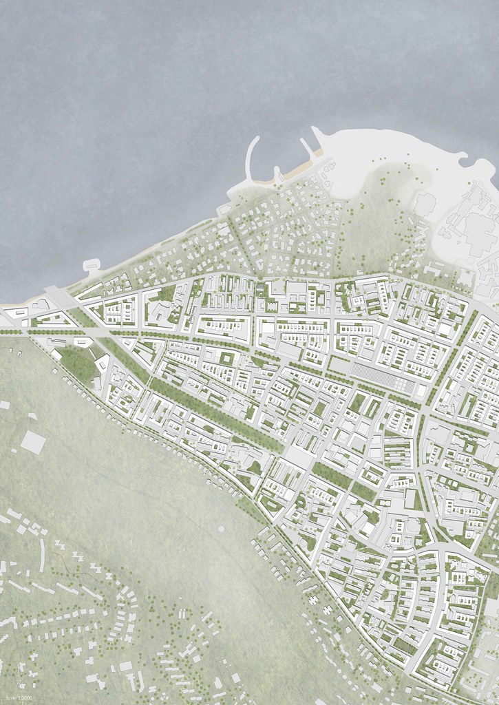
The Project is in the north of Israel, in the city Haifa. Due to the location next to the Mediterranean Sea, the area is characterized by its surroundings, especially the Mount Carmel. The district of Kiryat Eliezer is built as a Garden city, with pure residential areas, made of copy and paste buildings, placed in rows, leaving lots of dead spaces in between. Railroad tracks and a highway separate the area, forming an invisible border right through the city, isolating the neighborhood. With our project “dencity” we want to connect the neighborhood of Kiryat Eliezer, densify with low rise building and improve the living environment of the area.
For making that possible it is important to improve the traffic network, new side streets must be created, added by smaller streets to the buildings, to divert the traffic from the highway. By turning the highway into a boulevard, the street will provide as a connection between the two street sides instead of separating the area. Therefore, the railroad tracks will be run underground and there will be two stations, one needs to be built new and for the second station the old bus station can be reused. A new tram lines around and through the area, connect the neighborhood with downtown.
To solve the problem of undefined spaces between building, the green needs to be separated between private and public. In the middle of the area is a big park, that will be redefined by clear park boundaries and expanded to the sea. Accordingly, the relationship to the sea will be highlighted. Small parks and streets connect the Carmel Mountain to the park. Squares at the beginning, the middle and the end of the park make the public space more diverse. For neighborhood interaction, new smaller squares are built next or inside the quarters. To make the boulevard interesting, at one point, the street opens up and forms another square.
The urban development will occur in two phases. At first, existing buildings will be renovated and expanded on one side. Thereby, the buildings get new facades, and the floor plans get renovated. Only a few buildings will be demolished to get a better city structure.
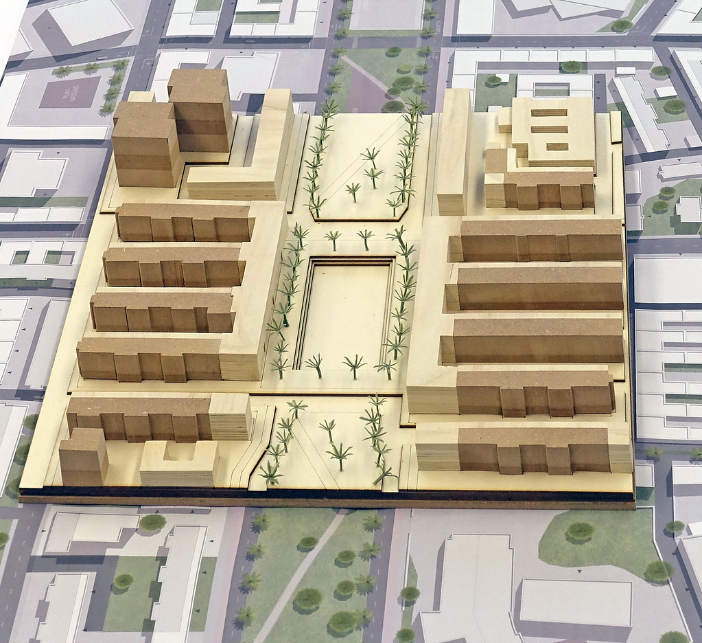
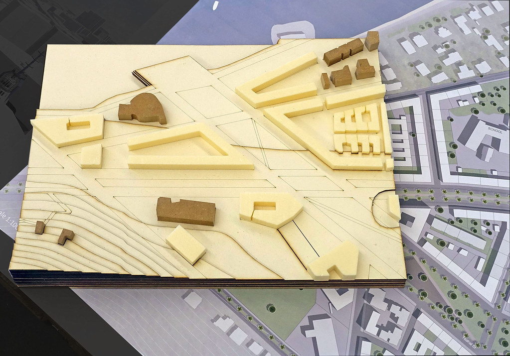
The second step will be densification, by connecting the existing buildings to block with perimeter building. Lower courtyard houses fill the gaps in between the buildings. In the area of the railroad tracks, completely new blocks are planned according to the same principle. Due to high densification the area can reach a gross total area (GFA) from 452.000 m2, a floor area index (FAR) of 1,78 and a base area (Coverage ratio) of 0,53.
Concept


Bahnhof (train station)
Master plan 1/1,000

Urban structure
By parceling the existing buildings, each house gets a private property, a small front garden and access through smaller roads. Passages through the block perimeter make the block better connected. To solve the parking problem in the neighborhood, there will be four parking garages build and there will be parking inside the blocks. To prevent a higher use of cars, new public transportation is contemplated.
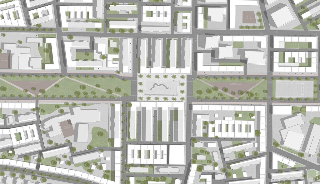
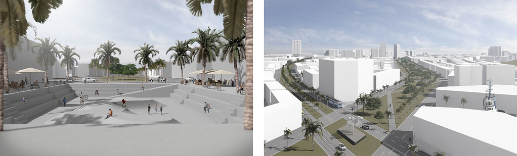
The heart of the landscape design is the park from the city to the sea, with a dock at the end. The park is outlined by a street, that is only accessible in one direction. Walkways in the middle of the park connect the streets. Activities are in between. In the beginning, the park starts with street soccer and basketball and an outdoor gym. The new center of the park will be a skater plaza with restaurants and cafés next to it. The skating area is framed by steps for sitting.
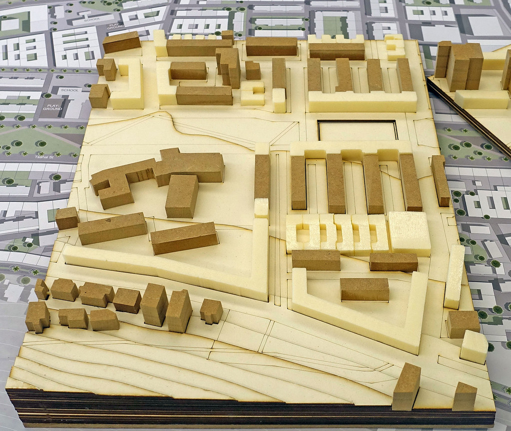
Many schools are around the area; therefore, playgrounds and a trampoline park will be planned near the schools. Moreover, there is planned a climbing park, a dog park, and a beach volleyball field by the sea. The city entrance is marked with a statue.
Public spaces are defined by tree rows out of palm trees. They are bordering the park, several avenues and provide shade against the heat. Another small park at the foot of the mountain marks paths up the Carmel and the connection to the Haifa Trail. A larger plaza at the side of the boulevard is bordered by new buildings and the existing bus station. It can be used for activities such as boules or basketball and is lined by palm trees for shade. The Museum close to the sea remains and will be extended with new buildings, forming a square in front.
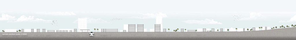
Section south-north 1/1,000

Urban detail 1/500 central green belt – Tayelet

Typologies
The block perimeter is mainly used with commercial on the ground floor and residential on the upper floors. There are some smaller commercials in the courtyards, and the inside of the blocks is exclusively for residential use. The block perimeter is built out of four-story buildings, and the courtyard buildings are only two stories high. Existing high-rise buildings will be retained for reasons of sustainability.
There is a lot of topography in the area. At the waterfront the level is mainly flat, and it‘s slowly rising towards the mountain. In the section through the boulevard, you can see wide bike and pedestrian lanes and a tramway, which can also be used for cars. In total there are four lanes for cars, divided by green in the middle with rows of palm trees and a footpath in the middle to give the street more quality. Buildings on both sides define the lines of the street. In the section through the park, you can see the roads on each side with traffic in one direction only. There is greenery in the middle. Rows of palm trees line the edges of the park; existing trees remain on the green areas, with the paths in between.
The floor plans show a new building with commercial uses on the ground floor at the edge of the square and residential us on the upper floors with a total of three apartments. They dispose about tree rooms and loggias. Passages underneath the buildings lead to the residential buildings.
For the existing buildings, there are two types. The first one is very narrow with outstanding balconies. The floor plans have two small apartments. With the extension of the building by three meters, the apartments get extended by a large living space and renewed by a new front facade. Furthermore, the buildings get new staircases with an elevator. The second type has an open ground floor with entrances hidden in the dark un-der the building. By closing the ground floor, the area gets use for community space. In the upper floors there is also an extension of the apartments by widening the building. The courtyard houses are smaller with two stories in front with only one unit. A hallway can reach the courtyard and a granny apartment in the side wing of the house with a roof terrace on top.

Central green belt – Tayelet

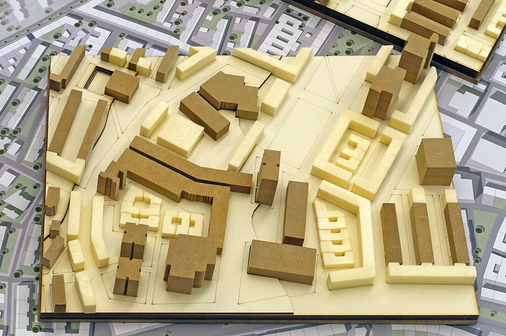
Models Urban Design

Scale 1/2,000 (towards west, from the inner city)
Central skateboard park at Tayelet

Scale 1/500
Meyerhoff Square

Scale 1/1,000
New Nakhal Street

Scale 1/1,000
New Carmel Beach Promenade with Clandestine Immigration and Naval Museum

Scale 1/1,000
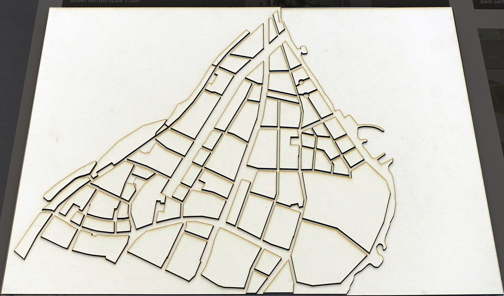
Morphologie (from west)

Scale 1/5,000
The Project is in the north of Israel, in the city Haifa. Due to the location next to the Mediterranean Sea, the area is characterized by its surroundings, especially the Mount Carmel. The district of Kiryat Eliezer is built as a Garden city, with pure residential areas, made of copy and paste buildings, placed in rows, leaving lots of dead spaces in between. Railroad tracks and a highway separate the area, forming an invisible border right through the city, isolating the neighborhood. With our project “dencity” we want to connect the neighborhood of Kiryat Eliezer, densify with low rise building and improve the living environment of the area.
For making that possible it is important to improve the traffic network, new side streets must be created, added by smaller streets to the buildings, to divert the traffic from the highway. By turning the highway into a boulevard, the street will provide as a connection between the two street sides instead of separating the area. Therefore, the railroad tracks will be run underground and there will be two stations, one needs to be built new and for the second station the old bus station can be reused. A new tram lines around and through the area, connect the neighborhood with downtown.
To solve the problem of undefined spaces between building, the green needs to be separated between private and public. In the middle of the area is a big park, that will be redefined by clear park boundaries and expanded to the sea. Accordingly, the relationship to the sea will be highlighted. Small parks and streets connect the Carmel Mountain to the park. Squares at the beginning, the middle and the end of the park make the public space more diverse. For neighborhood interaction, new smaller squares are built next or inside the quarters. To make the boulevard interesting, at one point, the street opens up and forms another square.
The urban development will occur in two phases. At first, existing buildings will be renovated and expanded on one side. Thereby, the buildings get new facades, and the floor plans get renovated. Only a few buildings will be demolished to get a better city structure.
The second step will be densification, by connecting the existing buildings to block with perimeter building. Lower courtyard houses fill the gaps in between the buildings. In the area of the railroad tracks, completely new blocks are planned according to the same principle. Due to high densification the area can reach a gross total area (GFA) from 452.000 m2, a floor area index (FAR) of 1,78 and a base area (Coverage ratio) of 0,53.
Concept
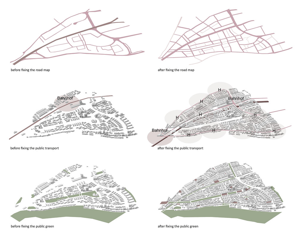

Bahnhof (train station)
Master plan 1/1,000

Urban structure
By parceling the existing buildings, each house gets a private property, a small front garden and access through smaller roads. Passages through the block perimeter make the block better connected. To solve the parking problem in the neighborhood, there will be four parking garages build and there will be parking inside the blocks. To prevent a higher use of cars, new public transportation is contemplated.
The heart of the landscape design is the park from the city to the sea, with a dock at the end. The park is outlined by a street, that is only accessible in one direction. Walkways in the middle of the park connect the streets. Activities are in between. In the beginning, the park starts with street soccer and basketball and an outdoor gym. The new center of the park will be a skater plaza with restaurants and cafés next to it. The skating area is framed by steps for sitting.
Many schools are around the area; therefore, playgrounds and a trampoline park will be planned near the schools. Moreover, there is planned a climbing park, a dog park, and a beach volleyball field by the sea. The city entrance is marked with a statue.
Public spaces are defined by tree rows out of palm trees. They are bordering the park, several avenues and provide shade against the heat. Another small park at the foot of the mountain marks paths up the Carmel and the connection to the Haifa Trail. A larger plaza at the side of the boulevard is bordered by new buildings and the existing bus station. It can be used for activities such as boules or basketball and is lined by palm trees for shade. The Museum close to the sea remains and will be extended with new buildings, forming a square in front.
Section south-north 1/1,000
Urban detail 1/500 central green belt – Tayelet
Typologies
The block perimeter is mainly used with commercial on the ground floor and residential on the upper floors. There are some smaller commercials in the courtyards, and the inside of the blocks is exclusively for residential use. The block perimeter is built out of four-story buildings, and the courtyard buildings are only two stories high. Existing high-rise buildings will be retained for reasons of sustainability.
There is a lot of topography in the area. At the waterfront the level is mainly flat, and it‘s slowly rising towards the mountain. In the section through the boulevard, you can see wide bike and pedestrian lanes and a tramway, which can also be used for cars. In total there are four lanes for cars, divided by green in the middle with rows of palm trees and a footpath in the middle to give the street more quality. Buildings on both sides define the lines of the street. In the section through the park, you can see the roads on each side with traffic in one direction only. There is greenery in the middle. Rows of palm trees line the edges of the park; existing trees remain on the green areas, with the paths in between.
The floor plans show a new building with commercial uses on the ground floor at the edge of the square and residential us on the upper floors with a total of three apartments. They dispose about tree rooms and loggias. Passages underneath the buildings lead to the residential buildings.
For the existing buildings, there are two types. The first one is very narrow with outstanding balconies. The floor plans have two small apartments. With the extension of the building by three meters, the apartments get extended by a large living space and renewed by a new front facade. Furthermore, the buildings get new staircases with an elevator. The second type has an open ground floor with entrances hidden in the dark un-der the building. By closing the ground floor, the area gets use for community space. In the upper floors there is also an extension of the apartments by widening the building. The courtyard houses are smaller with two stories in front with only one unit. A hallway can reach the courtyard and a granny apartment in the side wing of the house with a roof terrace on top.

Central green belt – Tayelet
Models Urban Design

Scale 1/2,000 (towards west, from the inner city)
Central skateboard park at Tayelet
Scale 1/500
Meyerhoff Square
Scale 1/1,000
New Nakhal Street
Scale 1/1,000
New Carmel Beach Promenade with Clandestine Immigration and Naval Museum
Scale 1/1,000
Morphologie (from west)
Scale 1/5,000
