MASTERSTUDIENGANG - ENVIRONMENTAL DESIGN
Haifa – From Wadi Salib to Neve Paz
Haifa – no edge – more flowHaifa – From Wadi Salib to Neve Paz
Pauline Lang, Lukas Vesper (Hochschule Bremen), Fall semester 2019/2020
In May 12th of 2021 the project was honored with the Recognition Award from local Chambre of Architects.
Am 12. Mai 2021 erhielt das Projekt eine Anerkennung beim BDA-Studienpreis Bremen.

Die Küstenstadt Haifa, in Israel, ist geprägt von ihrer Topografie des Karmel Gebirge und der Wasserkante zum Mittelmeer.
Mit einer Einwohnerzahl von ca. 280.000 Menschen ist Haifa die drittgrößte Stadt in Israel. Um die Stadtentwicklung fortzusetzen, gilt es die Potenziale und den Charakter der Stadt zu erkennen und auszuarbeiten.
Das Planungsgebiet befindet sich unmittelbar neben dem großen Hafengelände. Der Hafen von Haifa ist ein natürlicher Tiefwasserhafen und befindet sich in der langgezogenen Bucht am Mittelmeer, ist historisch von hoher Bedeutung und auch wirtschaftlich ein großer Faktor für das ganze Land.
Der Hafen wird das ganze Jahr von Passagier - und Frachtschiffen, sowie von dem Militär genutzt und angefahren.
Aufgrund der Umstrukturierung und dem Neubau eines Hafenbeckens, beginnt eine neue Entwicklungsphase und es stellt sich zunehmend die Frage, wie die Stadt Haifa das hohe Maß an potenziellen Flächen nutzen und in die bestehende Stadtstruktur einbinden kann.
Das aufeinander treffen von Topografie des Gebirges, Strand, Meer und Natur bilden eine vielseitige Symbiose die es zu berücksichtigen gilt.
Charakteristisch für die Topographie sind zwei Wadis (Täler) die ursprünglich unter natürlichen Voraussetzungen der Entwässerung des Gebirges dienten. Wadi Salib, einem arabischen Stadtteil und Wadi Rushmia, dem eine jüdische Herkunft zugeschrieben wird. Da die Hafenkante künstlich vorgezogen wurde, laufen diese nicht mehr zum Meer.
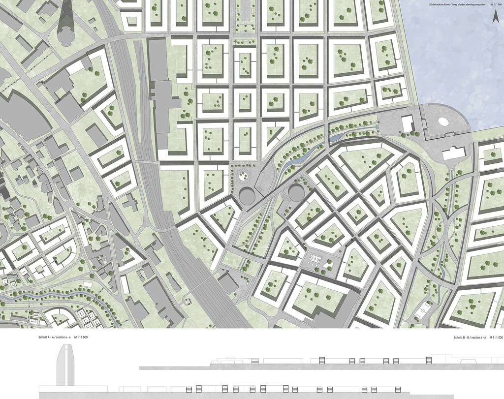
Im ersten Schritt der Analyse sind folgende Faktoren erkennbar geworden, es gibt eine deutliche Trennung von Wohnen, Gewerbe, Industrie, Arbeit und Verkehr.
Am Hang des Berges befinden sich überwiegend Wohnbebauung, Einzelhandel, sowie Nahversorgungsangebote. Am Hangfuß befinden sich Gewerbe, Handwerk und Industrielle Nutzungen, die mit der Lage der Zugstrecke eine gute Anbindung haben. Die Bahnlinie führt direkt an der Küstenlinie herum und führt zu einer Teilung im Bereich des Planungsgebietes.
Die Infrastrukturen für den motorisierten Individualverkehr führen mit sehr dominante n Straßenzüge und Brücken durch das Planungsgebiet, die somit eine Barriere darstellen und in der weiteren Entwurfsphase reduziert und umgeplant werden. Aufgrund der Topografie entstehen neue Situationen die mit steilen Straßen und langen Treppen zu überwinden sind.

The coastal city of Haifa, in Israel, is characterized by topography of the Carmel Mountains and the water edge to the Mediterranean Sea.
With a population of about 280,000 people, Haifa is the third largest city in Israel.
In order to continue the urban development, it is necessary to identify and elaborate the city's potential and character.
The planning area is located directly next to the large port area. The port of Haifa
is a natural deep-water port and is located in the bay on the Mediterranean Sea.
It is historically of great importance and also economically a factor for the whole country
The port is used and approached all the year by passenger and transport ships and the military
Due to the restructuring and the construction of a new port basin, a new phase of development is beginning and the question arises increasingly how the city of Haifa can use the high potential of land and integrate it into the existing urban structure. The meeting of the topography of the mountains, beach, sea and nature form a nice symbiosis which has to be considered
Characteristic for the topography are also two wadis (valleys) which originally served under natural conditions for the drainage of the mountains. Wadi Salib, an Arabic district and Wadi Rushmia, which is ascribed a Jewish origin. Since the edge of the harbor was artificially brought forward, they no longer run to the sea.
In the first step of the analysis the following factors have become apparent, there is a clear separation of residential, commercial, industrial/, employment and traffic.
On the slope of the mountain there are mainly residential/,
retail and local/ supply offers. At the foot of the slope there are commercia/, handicraft and industrial uses, which have good connections due to the location of the railway line.
The railway line runs directly along the coast line and leads to a division in the area of the planning area.
The infrastructure for motorized individual traffic leads with very dominant roads and bridges through the planning area, which therefore represent a barrier and will be reduced and redesigned in the further design phase.
Due to the topography, new situations arise which have to be overcome with steep roads and long stairs.


Scale 1:1,000
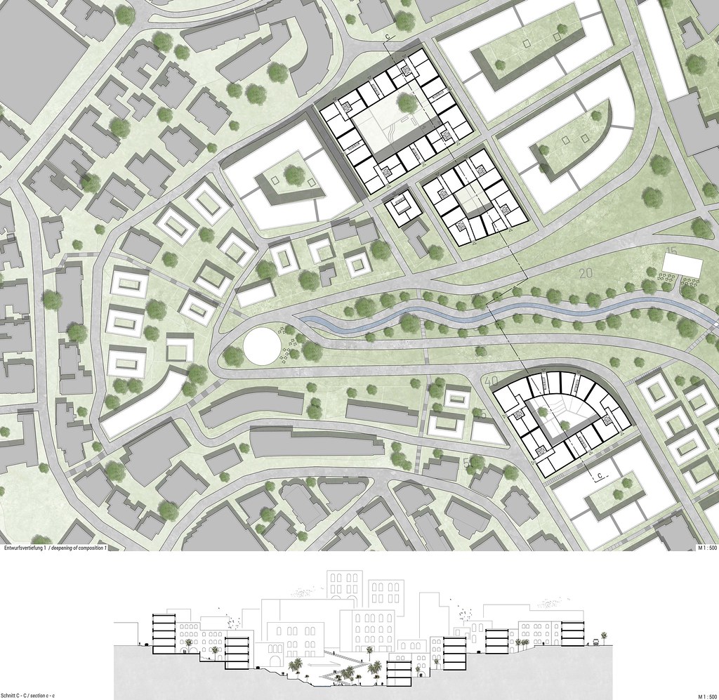
In dem Entwurf gilt es die verschiedenen Nutzungen, wie Wohnen, Gewerbe und Industrie zu Verbinden. Ursprünglich führten die beiden Wadis bis zum Meer. Diese Linie gilt es wiederherzustellen und somit den oberen Teil mit dem unteren Teil der Stadt zu verbinden und die aktuelle Trennung aufzuheben.
Die beiden Täler werden in Form eines organischen Freiraumes bis zum Meer weitergeführt. Der gleichzeitig als Aufenthaltsraum, aber auch als Infrastruktur dient.
Der Bestand am Hang des Berges gilt als Charakteristisch und auch Stellenweise, wie zum Beispiel der Stadtteil Wadi Salib, als historisch und wird nur punktuell ergänzt, um die Räume zu verdichten. Weiter unten teilt sich die Bebauung und wird durch Blockrandbebauung definiert.
Die Typologien sind hauptsächlich als Wohn- und Geschäftshaus ausgebildet, es sind-nicht mehr als vier Geschosse vorgesehen. Ausnahmen sind die Platzsituationen, wo angrenzende Gebäude ein zusätzliches Geschoss erhalten. Somit sind Plätze auch aus der Entfernung zu erkennen und bieten mehr Schatten. Die Situation bergab ist auch in der Dachaufsicht zu sehen, wo der Versatz auf die Höhenunterschiede reagiert.
Der Freiraum steht mit seiner organischen Form im Kontrast zu der homogenen Blockrandbebauung und soll die ehemals natürliche Entwässerung des Gebirges darstellen und auch als solche funktionieren. Außerdem wird dieser um drei Meter gesenkt um den Charakter der ehemaligen Entwässerung zu Verstärken und auch um dem langsamen Verkehr eine eigene Plattform zu geben.
Die Hauptverkehrsführungen verlaufen mit den Höhenlinien und sind einer der Hauptgründe der Trennung des Planungsgebietes. Der motorisierte Verkehr wird mit Brücken über den Freiraum geführt. Für Fußgänger bieten die markanten „Shortcuts", die auch aktuell das Stadtbild prägen, weiterhin die Möglichkeit Hang abwärts die Treppe hinunterzusteigen.

In the design, the various uses, such as residential/, commercial and industrial/, are to be combined. Originally the two wadis led to the sea.
The aim is to restore this line and thus connect the upper part with the lower part of the city and abolish the current separation.
The two valleys will be continued to the sea in the form of an organic open space.
At the same time, it will serve as a recreation room, but also as an infrastructure.
The existing structure on the slope of the mountain is considered characteristic and also places, such as the Wadi Salib district, are considered historical and will only be added to selectively in order to condense the spaces. Further down the development is divided and is defined by perimeter block development.
The typologies are mainly residential and commercial buildings, no more than four stories are planned. Exceptions are the square situations where adjacent buildings have an additional floor. In this way, squares can be seen from a distance and offer more shade. The situation downhill can also be seen in the roof view, where the offset reacts to the differences in height.
With its organic form, the open space contrasts with the homogeneous block edge development and is intended to represent the former natural drainage of the mountains and also function as such. In addition, it will be lowered by three meters to reinforce the character of the former drainage and also to give the slow traffic its own platform.
The main traffic routes run with the contour lines and are one of the main reasons for the separation of the planning area. The motorized traffic is guided over the open space by bridges. For pedestrians, the distinctive „shortcuts':
which also currently characterize the cityscape, continue to offer the possibility of descending the slope down the stairs.
Scale 1:500


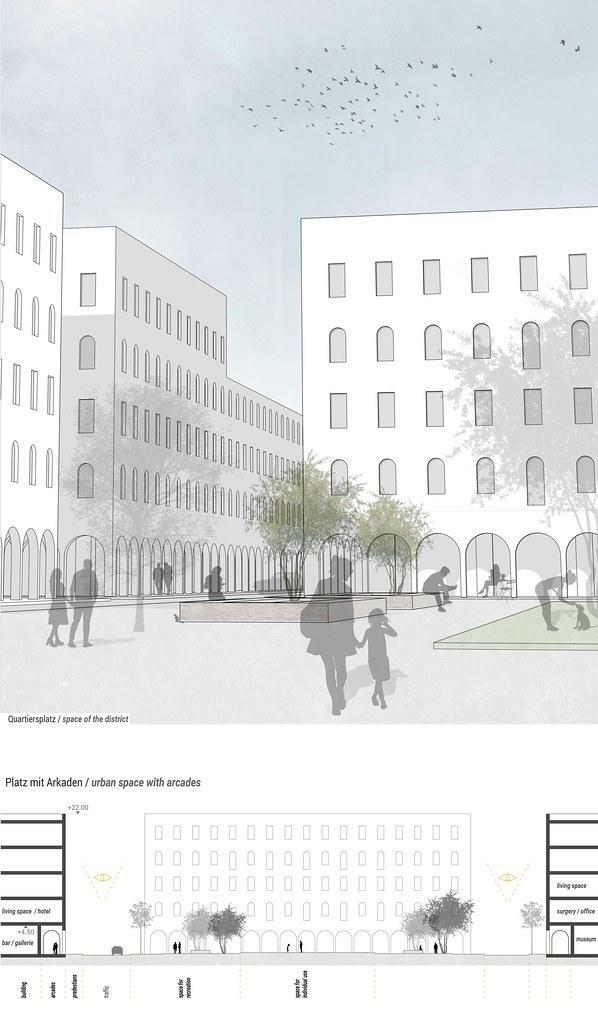

Im Entwurf entstehen verschiedenen Situationen, die den öffentlichen Raum beeinflussen und gestalten. Um entsprechende Faktoren, wie die Lärmentwicklung, Sichtbeziehungen und die Nutzung im Quartier zu berücksichtigen, sind unterschiedliche Teilungen entstanden.
Der Freiraum, der als Erholungsgebiet funktioniert, setzt sich in die Tiefe ab und ermöglicht einen Blick auf das Meer. Die Verkehrsführung befindet sich auf dem darüber liegenden Niveau und wächst mithilfe von Brücken zu einem Erschließungsnetz zusammen.
Die Querung über die Bahnstrecke teilt sich in mehrere Abschnitte und löst die große bestehende Autobrücke ab. Somit werden neue Quartiere in die vorhandene Struktur eingebunden.
Die Bebauung zeigt eine klare Trennung zwischen Privat- und Öffentlichen Räumen, dies hat zur Folge das öffentliche Plätze in einem Urbanen und belebten Umfeld entstehen. Aufgrund der Nutzung, die für Cafés, Shops, Galerien oder weitere Dienstleistungen vorgesehen sind, ergibt sich die Gestaltung im Freiraum. Arkaden sorgen für die Verschattung und geben dem Platz damit ein präsentes Erscheinungsbild. Der Platz ist mithilfe verschiedener Oberflächen aufgeteilt, Pflastersteine, eine wassergebundene Sandoberfläche und Grünflächen geben unterschiedliche Funktionen vor. Sitzmöbeln und Bepflanzung, die für das israelische Klima passend sind, geben dem Ort eine hohe Aufenthaltsqualität und Raum für die individuelle Nutzung.
In dem neu geplanten Gebiet, entsteht eine Achse, die von dem Sail Tower bis zum Meer verläuft, dieser Raum wird mit der Gestaltung der Promenade, das Zentrum in dem Quartier bilden. Geschäfte und Dienstleistung, Bildungseinrichtungen und Wohnraum wird die Straße prägen und ein belebtes und städtisches Bild vermitteln. Weitere Achsen lassen immer wieder den Blick auf das Wasser zu und gibt die Möglichkeit, den Freiraum an der Wasserkante zu genießen.
Scale 1:500

In the design, various situations arise that influence and shape the public space. In order to take into account corresponding factors such as noise development, visual relations and the use in the neighborhood, different divisions have been created.
The open space, which functions as a recreational area, settles into the depths and allows a view of the sea. The traffic routing is at the level above and is growing together into a development network with the help of bridges.
The crossing over the railway line is divided into several sections and replaces the large existing motorway bridge.
This new quarters are integrated into the existing structure.
The development shows a clear separation between private and public spaces, which results in public spaces in an urban and lively environment. Due to the use intended for cafes, shops, galleries or other services, the design results in open space. Arcades provide shade and thus give the square a present appearance. The square is divided by means of different surfaces; cobblestones, a water-bound sand surface and green areas provide different functions.
Seating and planting, which are appropriate for the Israeli climate, give the place a high quality of stay and space for individual use. In the newly planned area, an axis will be created that runs from the Sail tower to the sea, and this space, together with the design of the promenade, will form the center of the quarter. Shops and services, educational institutions and living space will characterize the street and convey a lively and urban image. Further axes will allow a view of the water again and again and will give the opportunity to enjoy the open space at the water's edge.
Scale 1:500

Scale 1:1,000

Scale 1:2,500


